Weather Alert in New York
Lake Effect Snow Warning issued March 16 at 1:54PM EDT until March 18 at 8:00AM EDT by NWS Buffalo NY
AREAS AFFECTED: Oswego
DESCRIPTION: * WHAT...Heavy lake effect snow expected. Total snow accumulations 6 to 12 inches in the most persistent bands. Winds gusting up to 45 mph will produce blowing and drifting snow late tonight through Tuesday. There may be a brief period of sleet and freezing rain during the transition to snow this evening, with ice accumulations of up to a tenth of an inch in some areas. * WHERE...Oswego County. * WHEN...From 9 PM this evening to 8 AM EDT Wednesday. * IMPACTS...Travel will be difficult with snow covered roads and poor visibility. The hazardous conditions will impact the Tuesday morning and evening commutes. Gusty winds will down tree branches and cause isolated power outages. * ADDITIONAL DETAILS...A rapid drop in temperatures late this evening may produce very icy conditions on untreated roads, sidewalks, and parking lots.
INSTRUCTION: Heavy snow will fall in relatively narrow bands. If traveling, be prepared for rapidly changing road conditions and visibilities. Submit snow reports through our website or social media.
Want more detail? Get the Complete 7 Day and Night Detailed Forecast!
Current U.S. National Radar--Current
The Current National Weather Radar is shown below with a UTC Time (subtract 5 hours from UTC to get Eastern Time).

National Weather Forecast--Current
The Current National Weather Forecast and National Weather Map are shown below.

National Weather Forecast for Tomorrow
Tomorrow National Weather Forecast and Tomorrow National Weather Map are show below.

North America Water Vapor (Moisture)
This map shows recent moisture content over North America. Bright and colored areas show high moisture (ie, clouds); brown indicates very little moisture present; black indicates no moisture.

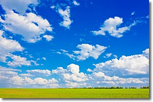
Weather Topic: What are Cumulus Clouds?
Home - Education - Cloud Types - Cumulus Clouds
 Next Topic: Drizzle
Cumulus clouds are fluffy and textured with rounded tops, and
may have flat bottoms. The border of a cumulus cloud
is clearly defined, and can have the appearance of cotton or cauliflower.
Cumulus clouds form at low altitudes (rarely above 2 km) but can grow very tall,
becoming cumulus congestus and possibly the even taller cumulonimbus clouds.
When cumulus clouds become taller, they have a greater chance of producing precipitation.
Next Topic: Drizzle
Weather Topic: What is Evaporation?
Home - Education - Precipitation - Evaporation
 Next Topic: Fog
Evaporation is the process which returns water from the earth
back to the atmosphere, and is another crucial process in the water cycle.
Evaporation is the transformation of liquid into gas, and it happens because
molecules are excited by the application of energy and turn into vapor.
In order for water to evaporate it has to be on the surface of a body of water.
Next Topic: Fog
Current conditions powered by WeatherAPI.com


