Weather Alert in New York
Lake Effect Snow Warning issued March 16 at 1:54PM EDT until March 18 at 8:00AM EDT by NWS Buffalo NY
AREAS AFFECTED: Oswego
DESCRIPTION: * WHAT...Heavy lake effect snow expected. Total snow accumulations 6 to 12 inches in the most persistent bands. Winds gusting up to 45 mph will produce blowing and drifting snow late tonight through Tuesday. There may be a brief period of sleet and freezing rain during the transition to snow this evening, with ice accumulations of up to a tenth of an inch in some areas. * WHERE...Oswego County. * WHEN...From 9 PM this evening to 8 AM EDT Wednesday. * IMPACTS...Travel will be difficult with snow covered roads and poor visibility. The hazardous conditions will impact the Tuesday morning and evening commutes. Gusty winds will down tree branches and cause isolated power outages. * ADDITIONAL DETAILS...A rapid drop in temperatures late this evening may produce very icy conditions on untreated roads, sidewalks, and parking lots.
INSTRUCTION: Heavy snow will fall in relatively narrow bands. If traveling, be prepared for rapidly changing road conditions and visibilities. Submit snow reports through our website or social media.
Want more detail? Get the Complete 7 Day and Night Detailed Forecast!
Current U.S. National Radar--Current
The Current National Weather Radar is shown below with a UTC Time (subtract 5 hours from UTC to get Eastern Time).

National Weather Forecast--Current
The Current National Weather Forecast and National Weather Map are shown below.

National Weather Forecast for Tomorrow
Tomorrow National Weather Forecast and Tomorrow National Weather Map are show below.

North America Water Vapor (Moisture)
This map shows recent moisture content over North America. Bright and colored areas show high moisture (ie, clouds); brown indicates very little moisture present; black indicates no moisture.

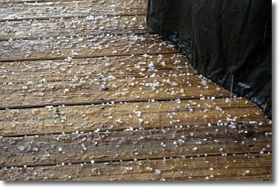
Weather Topic: What is Sleet?
Home - Education - Precipitation - Sleet
 Next Topic: Snow
Sleet is a form of precipitation in which small ice pellets are the primary
components. These ice pellets are smaller and more translucent than hailstones,
and harder than graupel. Sleet is caused by specific atmospheric conditions and
therefore typically doesn't last for extended periods of time.
The condition which leads to sleet formation requires a warmer body of air to be
wedged in between two sub-freezing bodies of air. When snow falls through a warmer
layer of air it melts, and as it falls through the next sub-freezing body of air
it freezes again, forming ice pellets known as sleet. In some cases, water
droplets don't have time to freeze before reaching the surface and the result is
freezing rain.
Next Topic: Snow
Weather Topic: What are Stratocumulus Clouds?
Home - Education - Cloud Types - Stratocumulus Clouds
 Next Topic: Stratus Clouds
Stratocumulus clouds are similar to altocumulus clouds in their
fluffy appearance, but have a slightly darker shade due to their additional mass.
A good way to distinguish the two cloud types is to hold your hand out and measure
the size of an individual cloud; if it is the size of your thumb it is generally
an altocumulus cloud, if it is the size of your hand it is generally a
stratocumulus cloud.
It is uncommon for stratocumulus clouds to produce precipitation, but if they do
it is usually a light rain or snow.
Next Topic: Stratus Clouds
Current conditions powered by WeatherAPI.com


