Weather Alert in Texas
Special Weather Statement issued August 3 at 1:01PM CDT by NWS Fort Worth TX
AREAS AFFECTED: Denton; Collin; Tarrant; Dallas; Johnson; Ellis
DESCRIPTION: At 100 PM CDT, Doppler radar was tracking strong thunderstorms along a line extending from near Prosper to near Godley. Movement was southeast at 20 mph. HAZARD...Wind gusts up to 50 mph and pea size hail. SOURCE...Radar indicated. IMPACT...Gusty winds could knock down tree limbs and blow around unsecured objects. Minor damage to outdoor objects is possible. Strong thunderstorms will be near... Dallas, Fort Worth, Arlington, Irving, Carrollton, Frisco, Lewisville, Flower Mound, Euless, and Bedford around 105 PM CDT. Plano, Grand Prairie, McKinney, Mansfield, and Keene around 110 PM CDT. Farmers Branch around 115 PM CDT. Allen and Addison around 120 PM CDT. Alvarado around 125 PM CDT. Other locations impacted by these storms include Lake Arlington, Rio Vista, Parker, Joe Pool Lake, Mountain Creek Lake, Sand Flat, Egan, Lillian, Lewisville Lake, and New Hope. This includes the following highways... Interstate 35W between mile markers 17 and 49. Interstate 35E between mile markers 428 and 456. Interstate 20 between mile markers 435 and 461. Interstate 30 between mile markers 17 and 44.
INSTRUCTION: If outdoors, consider seeking shelter inside a building. Torrential rainfall is also occurring with these storms and may lead to localized flooding. Do not drive your vehicle through flooded roadways. Frequent cloud to ground lightning is occurring with these storms. Lightning can strike 10 miles away from a thunderstorm. Seek a safe shelter inside a building or vehicle.
Want more detail? Get the Complete 7 Day and Night Detailed Forecast!
Current U.S. National Radar--Current
The Current National Weather Radar is shown below with a UTC Time (subtract 5 hours from UTC to get Eastern Time).

National Weather Forecast--Current
The Current National Weather Forecast and National Weather Map are shown below.

National Weather Forecast for Tomorrow
Tomorrow National Weather Forecast and Tomorrow National Weather Map are show below.

North America Water Vapor (Moisture)
This map shows recent moisture content over North America. Bright and colored areas show high moisture (ie, clouds); brown indicates very little moisture present; black indicates no moisture.

Weather Topic: What is Snow?
Home - Education - Precipitation - Snow
 Next Topic: Stratocumulus Clouds
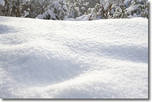
Snow is precipitation taking the form of ice crystals. Each ice crystal, or snowflake,
has unique characteristics, but all of them grow in a hexagonal structure.
Snowfall can last for sustained periods of time and result in significant buildup
of snow on the ground.
On the earth's surface, snow starts out light and powdery, but as it begins to melt
it tends to become more granular, producing small bits of ice which have the consistency of
sand. After several cycles of melting and freezing, snow can become very dense
and ice-like, commonly known as snow pack.
Next Topic: Stratocumulus Clouds
Weather Topic: What are Stratus Clouds?
Home - Education - Cloud Types - Stratus Clouds
 Next Topic: Wall Clouds
Stratus clouds are similar to altostratus clouds, but form at a
lower altitude and are identified by their fog-like appearance, lacking the
distinguishing features of most clouds.
Stratus clouds are wider than most clouds, and their base has a smooth, uniform
look which is lighter in color than a nimbostratus cloud.
The presence of a stratus cloud indicates the possibility of minor precipitation,
such as drizzle, but heavier precipitation does not typically arrive in the form
of a stratus cloud.
Next Topic: Wall Clouds
Current conditions powered by WeatherAPI.com


