Weather Alert in Minnesota
Winter Weather Advisory issued February 27 at 11:59AM CST until February 28 at 6:00PM CST by NWS La Crosse WI
AREAS AFFECTED: Wabasha; Winona; Buffalo; Trempealeau; Jackson; La Crosse; Monroe; Juneau; Adams
DESCRIPTION: ...BAND OF SNOW MOVES IN SATURDAY MORNING... .A narrow band of snow will move in from the west on Saturday morning and continue throughout much of the daytime hours. Snowfall rates of an inch an hour will be possible within the band resulting in quick accumulations on roadways. Snowfall amounts within the band will likely range between 2 to 4 inches with locally higher amounts of up to 6 inches possible. The exact location of the heaviest amounts still remains uncertain with a sharp cutoff in amounts possible over just a few miles. As a result, be sure to continue to monitor the forecast for updates as the location of snowfall amounts may still shift. * WHAT...Snow expected. Total snow accumulations between 1 and 4 inches. Locally higher amounts will be possible. * WHERE...Portions of southeast Minnesota and central and west central Wisconsin. * WHEN...From 6 AM to 6 PM CST Saturday. * IMPACTS...Plan on slippery road conditions.
INSTRUCTION: Slow down and use caution while traveling. In Minnesota, visit 511mn.org for road conditions. In Wisconsin, visit 511wi.gov for road conditions.
Want more detail? Get the Complete 7 Day and Night Detailed Forecast!
Current U.S. National Radar--Current
The Current National Weather Radar is shown below with a UTC Time (subtract 5 hours from UTC to get Eastern Time).

National Weather Forecast--Current
The Current National Weather Forecast and National Weather Map are shown below.

National Weather Forecast for Tomorrow
Tomorrow National Weather Forecast and Tomorrow National Weather Map are show below.

North America Water Vapor (Moisture)
This map shows recent moisture content over North America. Bright and colored areas show high moisture (ie, clouds); brown indicates very little moisture present; black indicates no moisture.

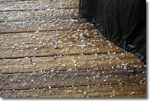
Weather Topic: What is Sleet?
Home - Education - Precipitation - Sleet
 Next Topic: Snow
Sleet is a form of precipitation in which small ice pellets are the primary
components. These ice pellets are smaller and more translucent than hailstones,
and harder than graupel. Sleet is caused by specific atmospheric conditions and
therefore typically doesn't last for extended periods of time.
The condition which leads to sleet formation requires a warmer body of air to be
wedged in between two sub-freezing bodies of air. When snow falls through a warmer
layer of air it melts, and as it falls through the next sub-freezing body of air
it freezes again, forming ice pellets known as sleet. In some cases, water
droplets don't have time to freeze before reaching the surface and the result is
freezing rain.
Next Topic: Snow
Weather Topic: What are Stratocumulus Clouds?
Home - Education - Cloud Types - Stratocumulus Clouds
 Next Topic: Stratus Clouds
Stratocumulus clouds are similar to altocumulus clouds in their
fluffy appearance, but have a slightly darker shade due to their additional mass.
A good way to distinguish the two cloud types is to hold your hand out and measure
the size of an individual cloud; if it is the size of your thumb it is generally
an altocumulus cloud, if it is the size of your hand it is generally a
stratocumulus cloud.
It is uncommon for stratocumulus clouds to produce precipitation, but if they do
it is usually a light rain or snow.
Next Topic: Stratus Clouds
Current conditions powered by WeatherAPI.com


