Weather Alert in California
Winter Weather Advisory issued February 18 at 2:32PM PST until February 19 at 10:00AM PST by NWS Medford OR
AREAS AFFECTED: Central Siskiyou County
DESCRIPTION: ...ANOTHER EPISODE OF LOW ELEVATION SNOW LATE TONIGHT INTO THURSDAY... .Scattered to numerous light snow showers will persist through this evening with snow levels around 1500 to 2000 feet and accumulation of up to 2 inches. The next cold front will follow with widespread accumulations of snow late tonight into Thursday morning and snow levels around 1000 to 1500 feet. Light snow showers will then taper off into Thursday afternoon while snow levels rise to 2000 feet, except for snow showers lingering into Thursday evening for eastern Klamath, Lake, and Modoc Counties. * WHAT...Snow. Additional snow accumulations 1 to 3 inches. A majority of the snow is expected from 2 AM PST to 8 AM PST on Thursday morning, with light snow showers then tapering off through the morning. * WHERE...Central Siskiyou County. Including the locations of...Hilt, Klamath River, Yreka, Weed as well as I-5 and portions of Highways 97, 96 and 3. This also includes the following passes or notable locations... Forrest Mountain Summit on state highway 3 at 4100 ft. * WHEN...Until 10 AM PST Thursday. * IMPACTS...Travel may be difficult and delays in your commute. The hazardous conditions could impact the Thursday morning commute. * ADDITIONAL DETAILS... Visit weather.gov/mfr/winter for additional snow probabilities
INSTRUCTION: Slow down and use caution while traveling. Call 511 or visit quickmap.dot.ca.gov for road information.
Want more detail? Get the Complete 7 Day and Night Detailed Forecast!
Current U.S. National Radar--Current
The Current National Weather Radar is shown below with a UTC Time (subtract 5 hours from UTC to get Eastern Time).

National Weather Forecast--Current
The Current National Weather Forecast and National Weather Map are shown below.

National Weather Forecast for Tomorrow
Tomorrow National Weather Forecast and Tomorrow National Weather Map are show below.

North America Water Vapor (Moisture)
This map shows recent moisture content over North America. Bright and colored areas show high moisture (ie, clouds); brown indicates very little moisture present; black indicates no moisture.

Weather Topic: What is Precipitation?
Home - Education - Precipitation - Precipitation
 Next Topic: Rain
Precipitation can refer to many different forms of water that
may fall from clouds. Precipitation occurs after a cloud has become saturated to
the point where its water particles are more dense than the air below the cloud.
In most cases, precipitation will reach the ground, but it is not uncommon for
precipitation to evaporate before it reaches the earth's surface.
When precipitation evaporates before it contacts the ground it is called Virga.
Graupel, hail, sleet, rain, drizzle, and snow are forms of precipitation, but fog
and mist are not considered precipitation because the water vapor which
constitutes them isn't dense enough to fall to the ground.
Next Topic: Rain
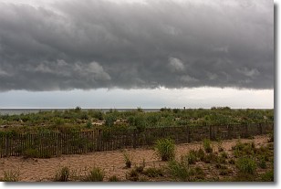
Weather Topic: What are Shelf Clouds?
Home - Education - Cloud Types - Shelf Clouds
 Next Topic: Sleet
A shelf cloud is similar to a wall cloud, but forms at the front
of a storm cloud, instead of at the rear, where wall clouds form.
A shelf cloud is caused by a series of events set into motion by the advancing
storm; first, cool air settles along the ground where precipitation has just fallen.
As the cool air is brought in, the warmer air is displaced, and rises above it,
because it is less dense. When the warmer air reaches the bottom of the storm cloud,
it begins to cool again, and the resulting condensation is a visible shelf cloud.
Next Topic: Sleet
Current conditions powered by WeatherAPI.com


