Weather Alert in Michigan
Hydrologic Outlook issued February 17 at 9:43AM EST by NWS Grand Rapids MI
AREAS AFFECTED: Allegan, MI; Barry, MI; Calhoun, MI; Clinton, MI; Eaton, MI; Ingham, MI; Ionia, MI; Jackson, MI; Kalamazoo, MI; Kent, MI; Muskegon, MI; Ottawa, MI; Van Buren, MI
DESCRIPTION: ESFGRR Steady melting of snow and ice over the last week has begun to cause rivers to rise across the area. Several chances for rain this week will add to these rises. Based on current expected rainfall, no significant flooding is expected on West Michigan rivers, though typical spring water level rises within the river channels will happen. Meanwhile, river ice has weakened significantly over the last week, and as water levels rise any remaining ice will likely be broken and start to move downstream. This creates the possibility for formation of a few ice jams. Ice jams tend to form in the same places repeatedly, so special attention should be paid in the Comstock Park (Kent County) area as well as the Robinson Township (Ottawa County) area along the Grand River. Anyone living or working near West Michigan rivers should pay extra attention this week as water levels rise. Have a plan to monitor and respond if flooding develops unexpectedly. Monitor the latest conditions at https://water.noaa.gov
INSTRUCTION: N/A
Want more detail? Get the Complete 7 Day and Night Detailed Forecast!
Current U.S. National Radar--Current
The Current National Weather Radar is shown below with a UTC Time (subtract 5 hours from UTC to get Eastern Time).

National Weather Forecast--Current
The Current National Weather Forecast and National Weather Map are shown below.

National Weather Forecast for Tomorrow
Tomorrow National Weather Forecast and Tomorrow National Weather Map are show below.

North America Water Vapor (Moisture)
This map shows recent moisture content over North America. Bright and colored areas show high moisture (ie, clouds); brown indicates very little moisture present; black indicates no moisture.

Weather Topic: What are Fractus Clouds?
Home - Education - Cloud Types - Fractus Clouds
 Next Topic: Freezing Rain
A fractus cloud (scud) is a fragmented, tattered cloud which has
likely been sheared off of another cloud. They are accessory clouds, meaning they
develop from parent clouds, and are named in a way which describes the original
cloud which contained them.
Fractus clouds which have originated from cumulus clouds are referred to as
cumulus fractus, while fractus clouds which have originated from stratus clouds
are referred to as stratus fractus. Under certain conditions a fractus cloud might
merge with another cloud, or develop into a cumulus cloud, but usually a
fractus cloud seen by itself will dissipate rapidly.
They are often observed on the leading and trailing edges of storm clouds,
and are a display of wind activity.
Next Topic: Freezing Rain
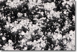
Weather Topic: What is Graupel?
Home - Education - Precipitation - Graupel
 Next Topic: Hail
Graupel is a form of precipitation that is created by atmospheric conditions
which cause supercooled water droplets to contact snow crystals and freeze to
their surface.
Sometimes known as soft hail or snow pellets, graupel is delicate and easily
destroyed by touch. Whereas hail usually falls during severe weather, graupel
doesn't require such conditions to form, and can form in mild precipitation
similar to situations which produce snowfall.
Next Topic: Hail
Current conditions powered by WeatherAPI.com


