Weather Alert in Maryland
Severe Thunderstorm Watch issued March 16 at 10:13PM EDT until March 17 at 12:00AM EDT by NWS Wakefield VA
AREAS AFFECTED: Dorchester, MD; Somerset, MD; Wicomico, MD; Worcester, MD; Camden, NC; Chowan, NC; Currituck, NC; Gates, NC; Pasquotank, NC; Perquimans, NC; Accomack, VA; Gloucester, VA; Isle of Wight, VA; James City, VA; Lancaster, VA; Mathews, VA; Middlesex, VA; Northampton, VA; Northumberland, VA; York, VA; City of Chesapeake, VA; City of Hampton, VA; City of Newport News, VA; City of Norfolk, VA; City of Poquoson, VA; City of Portsmouth, VA; City of Suffolk, VA; City of Virginia Beach, VA; City of Williamsburg, VA
DESCRIPTION: SEVERE THUNDERSTORM WATCH 71 REMAINS VALID UNTIL MIDNIGHT EDT TONIGHT FOR THE FOLLOWING AREAS IN MARYLAND THIS WATCH INCLUDES 4 COUNTIES IN SOUTHEAST MARYLAND DORCHESTER SOMERSET WICOMICO WORCESTER IN NORTH CAROLINA THIS WATCH INCLUDES 6 COUNTIES IN NORTHEAST NORTH CAROLINA CAMDEN CHOWAN CURRITUCK GATES PASQUOTANK PERQUIMANS IN VIRGINIA THIS WATCH INCLUDES 19 COUNTIES IN EASTERN VIRGINIA LANCASTER MATHEWS MIDDLESEX NORTHAMPTON NORTHUMBERLAND IN SOUTHEAST VIRGINIA ACCOMACK CITY OF CHESAPEAKE CITY OF HAMPTON CITY OF NEWPORT NEWS CITY OF NORFOLK CITY OF POQUOSON CITY OF PORTSMOUTH CITY OF SUFFOLK CITY OF VIRGINIA BEACH CITY OF WILLIAMSBURG GLOUCESTER ISLE OF WIGHT JAMES CITY YORK THIS INCLUDES THE CITIES OF BAVON, BOWERS HILL, BUSCH GARDENS, CAMBRIDGE, CAPE CHARLES, CAPE COLONY, CENTERVILLE, CHESAPEAKE AIRPORT, CHINCOTEAGUE, CHRISTENSONS CORNER, CRISFIELD, CROAKER, CURRITUCK, DEEP CREEK, EDENTON, ELIZABETH CITY, EWELL, EXMORE, FENTRESS, FIVE FORKS, GATESVILLE, GLOUCESTER POINT, GREAT BRIDGE, GREENBACKVILLE, GREENBRIER, GROVE, HAMPTON, HANCOCK, HERTFORD, HORNTOWN, HORSESHOE, KILMARNOCK, LANCASTER, LEWISETTA, LILLY, MACEDONIA, MAVATON, MOUNT PLEASANT, NEW CHURCH, NEW POINT, NEW POINT COMFORT, NEWPORT NEWS, NORFOLK, OCEAN CITY, ONANCOCK, PEARY, POQUOSON, PORTSMOUTH, PRINCESS ANNE, SAINT JOHNS, SALISBURY, SHARON, SMITHFIELD, SUFFOLK, URBANNA, VALHALLA, VIRGINIA BEACH, WILLIAMSBURG, AND YORKTOWN.
INSTRUCTION: N/A
Want more detail? Get the Complete 7 Day and Night Detailed Forecast!
Current U.S. National Radar--Current
The Current National Weather Radar is shown below with a UTC Time (subtract 5 hours from UTC to get Eastern Time).

National Weather Forecast--Current
The Current National Weather Forecast and National Weather Map are shown below.

National Weather Forecast for Tomorrow
Tomorrow National Weather Forecast and Tomorrow National Weather Map are show below.

North America Water Vapor (Moisture)
This map shows recent moisture content over North America. Bright and colored areas show high moisture (ie, clouds); brown indicates very little moisture present; black indicates no moisture.

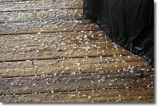
Weather Topic: What is Sleet?
Home - Education - Precipitation - Sleet
 Next Topic: Snow
Sleet is a form of precipitation in which small ice pellets are the primary
components. These ice pellets are smaller and more translucent than hailstones,
and harder than graupel. Sleet is caused by specific atmospheric conditions and
therefore typically doesn't last for extended periods of time.
The condition which leads to sleet formation requires a warmer body of air to be
wedged in between two sub-freezing bodies of air. When snow falls through a warmer
layer of air it melts, and as it falls through the next sub-freezing body of air
it freezes again, forming ice pellets known as sleet. In some cases, water
droplets don't have time to freeze before reaching the surface and the result is
freezing rain.
Next Topic: Snow
Weather Topic: What are Stratocumulus Clouds?
Home - Education - Cloud Types - Stratocumulus Clouds
 Next Topic: Stratus Clouds
Stratocumulus clouds are similar to altocumulus clouds in their
fluffy appearance, but have a slightly darker shade due to their additional mass.
A good way to distinguish the two cloud types is to hold your hand out and measure
the size of an individual cloud; if it is the size of your thumb it is generally
an altocumulus cloud, if it is the size of your hand it is generally a
stratocumulus cloud.
It is uncommon for stratocumulus clouds to produce precipitation, but if they do
it is usually a light rain or snow.
Next Topic: Stratus Clouds
Current conditions powered by WeatherAPI.com


