Weather Alert in Nebraska
Dust Advisory issued February 17 at 2:05PM MST until February 17 at 4:00PM MST by NWS Cheyenne WY
AREAS AFFECTED: Scotts Bluff, NE; Sioux, NE; Goshen, WY
DESCRIPTION: The National Weather Service in Cheyenne has issued a * Dust Advisory for... Northern Scotts Bluff County in the Panhandle of Nebraska... Southern Sioux County in the Panhandle of Nebraska... East central Goshen County in southeastern Wyoming... * Until 400 PM MST. * At 201 PM MST, an area of blowing dust was located between Torrington and Scottsbluff. HAZARD...Less than two miles visibility with strong wind in excess of 50 mph. SOURCE...Satellite imagery. IMPACT...Hazardous travel. Those driving along or near Highway 26 could see reduced visibility due to blowing dust. Locations impacted include... Scottsbluff, Torrington, Mitchell, Morrill, Lyman, Yoder, Henry, Huntley, Lake Minatare State Recreation Area, Lake Alice Number 2, Southern Hills Estates, Scotts Bluff County Fairground, Torrington Municipal Airport, Lake Alice, Scottsbluff Airport, and Goshen County Fairgrounds.
INSTRUCTION: Blowing dust brings reduced visibility, leading to dangerous driving conditions. If driving, avoid blowing dust if possible. If caught in dense blowing dust, pull off the road, turn off your lights and keep your foot off the brake.
Want more detail? Get the Complete 7 Day and Night Detailed Forecast!
Current U.S. National Radar--Current
The Current National Weather Radar is shown below with a UTC Time (subtract 5 hours from UTC to get Eastern Time).

National Weather Forecast--Current
The Current National Weather Forecast and National Weather Map are shown below.

National Weather Forecast for Tomorrow
Tomorrow National Weather Forecast and Tomorrow National Weather Map are show below.

North America Water Vapor (Moisture)
This map shows recent moisture content over North America. Bright and colored areas show high moisture (ie, clouds); brown indicates very little moisture present; black indicates no moisture.

Weather Topic: What is Drizzle?
Home - Education - Precipitation - Drizzle
 Next Topic: Evaporation
Drizzle is precipitation in the form of water droplets which are
smaller than raindrops.
Drizzle is characterized by fine, gently falling droplets and typically does not
impact human habitation in a negative way. The exception to this is freezing drizzle,
a condition where drizzle freezes immediately upon reaching earth's surface.
Freezing drizzle is still less dangerous than freezing rain, but can
potentially result in hazardous road conditions.
Next Topic: Evaporation
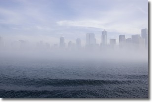
Weather Topic: What is Fog?
Home - Education - Cloud Types - Fog
 Next Topic: Fractus Clouds
Fog is technically a type of stratus cloud, which lies along the
ground and obscures visibility.
It is usually created when humidity in the air condenses into tiny water droplets.
Because of this, some places are more prone to foggy weather, such as regions
close to a body of water.
Fog is similar to mist; both are the appearance of water droplets suspended in
the air, but fog is the term applied to the condition when visibility is less than 1 km.
Next Topic: Fractus Clouds
Current conditions powered by WeatherAPI.com


