Weather Alert in Alabama
Flood Advisory issued August 21 at 6:28PM CDT until August 21 at 9:30PM CDT by NWS Birmingham AL
AREAS AFFECTED: Montgomery, AL
DESCRIPTION: * WHAT...Urban and small stream flooding caused by excessive rainfall is expected. * WHERE...Portions of Northwest Montgomery County in Alabama. * WHEN...Until 930 PM CDT. * IMPACTS...Minor flooding in low-lying and poor drainage areas. Water over roadways. Overflowing poor drainage areas. Ponding of water in urban or other areas is occurring or is imminent. * ADDITIONAL DETAILS... - At 628 PM CDT, Doppler radar indicated heavy rain due to thunderstorms. This will cause urban and small stream flooding. Between 1 and 1.5 inches of rain have fallen. - Additional rainfall amounts of 0.5 to 1 inch are expected over the area. This additional rain will result in minor flooding. - Some locations that will experience flooding include... Montgomery, Prattville, Coosada, Alabama State University, Alabama State Capitol, Montgomery Riverwalk Stadium, Hyundai Motors Of Alabama, Maxwell Air Force Base, Woodcrest, Pinedale, Montgomery Zoo, Hope Hull, Gunter Air Force Base, Boylston, Dannelly Field, Snowdoun, Hunter, Lagoon Park, Eastdale Mall and Auburn University In Montgomery.
INSTRUCTION: Turn around, don't drown when encountering flooded roads. Most flood deaths occur in vehicles. Be especially cautious at night when it is harder to recognize the dangers of flooding. Be aware of your surroundings and do not drive on flooded roads. Stay away or be swept away. River banks and culverts can become unstable and unsafe.
Want more detail? Get the Complete 7 Day and Night Detailed Forecast!
Current U.S. National Radar--Current
The Current National Weather Radar is shown below with a UTC Time (subtract 5 hours from UTC to get Eastern Time).

National Weather Forecast--Current
The Current National Weather Forecast and National Weather Map are shown below.

National Weather Forecast for Tomorrow
Tomorrow National Weather Forecast and Tomorrow National Weather Map are show below.

North America Water Vapor (Moisture)
This map shows recent moisture content over North America. Bright and colored areas show high moisture (ie, clouds); brown indicates very little moisture present; black indicates no moisture.

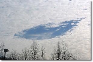
Weather Topic: What are Hole Punch Clouds?
Home - Education - Cloud Types - Hole Punch Clouds
 Next Topic: Mammatus Clouds
A hole punch cloud is an unusual occurrence when a disk-shaped
hole appears in a cirrostratus, cirrocumulus, or altocumulus cloud.
When part of the cloud forms ice crystals, water droplets in the surrounding area
of the cloud evaporate. The effect of this process produces a large elliptical
gap in the cloud. The hole punch cloud formation is rare, but it is not specific
to any geographic area.
Other names which have been used to describe this phenomena include fallstreak hole,
skypunch, and cloud hole.
Next Topic: Mammatus Clouds
Weather Topic: What are Nimbostratus Clouds?
Home - Education - Cloud Types - Nimbostratus Clouds
 Next Topic: Precipitation
A nimbostratus cloud is similar to a stratus cloud in its formless,
smooth appearance. However, a nimbostratus cloud is darker than a stratus cloud,
because it is thicker.
Unlike a stratus cloud, a nimbostratus cloud typically brings with it the threat
of moderate to heavy precipitation. In some cases, the precipitation may evaporate
before reaching the ground, a phenomenon known as virga.
Next Topic: Precipitation
Current conditions powered by WeatherAPI.com


