Weather Alert in Texas
Tornado Warning issued February 14 at 6:51PM CST until February 14 at 7:15PM CST by NWS Houston/Galveston TX
AREAS AFFECTED: Brazoria, TX; Galveston, TX; Harris, TX
DESCRIPTION: TORHGX The National Weather Service in League City has issued a * Tornado Warning for... Galveston County in southeastern Texas... Northeastern Brazoria County in southeastern Texas... Southeastern Harris County in southeastern Texas... * Until 715 PM CST. * At 650 PM CST, severe thunderstorms capable of producing both tornadoes and extensive straight line wind damage were located along a line extending from near South Belt / Ellington to 6 miles northeast of Bonney, moving east at 40 mph. HAZARD...Tornado. SOURCE...Radar indicated rotation. IMPACT...Flying debris will be dangerous to those caught without shelter. Mobile homes will be damaged or destroyed. Damage to roofs, windows, and vehicles will occur. Tree damage is likely. * These dangerous storms will be near... Southern Pasadena, League City, Friendswood, Alvin, Santa Fe, Webster, Clear Lake, southeastern South Belt / Ellington, Nassau Bay, and Hillcrest around 655 PM CST. Texas City, Dickinson, southern Seabrook, Hitchcock, Kemah, Taylor Lake Village, El Lago, Clear Lake Shores, and Kemah Boardwalk around 700 PM CST. La Marque and Bacliff around 705 PM CST. Other locations impacted by these tornadic storms include Chocolate Bayou.
INSTRUCTION: This Tornado Warning replaces the Severe Thunderstorm Warning issued for the same area. TAKE COVER NOW! Move to a basement or an interior room on the lowest floor of a sturdy building. Avoid windows. If you are outdoors, in a mobile home, or in a vehicle, move to the closest substantial shelter and protect yourself from flying debris. Tornadoes are extremely difficult to see and confirm at night. Do not wait to see or hear the tornado. TAKE COVER NOW! This line of thunderstorms is capable of producing tornadoes and widespread significant wind damage. Do not wait to see or hear the tornado. For your protection move to an interior room on the lowest floor of a building.
Want more detail? Get the Complete 7 Day and Night Detailed Forecast!
Current U.S. National Radar--Current
The Current National Weather Radar is shown below with a UTC Time (subtract 5 hours from UTC to get Eastern Time).

National Weather Forecast--Current
The Current National Weather Forecast and National Weather Map are shown below.

National Weather Forecast for Tomorrow
Tomorrow National Weather Forecast and Tomorrow National Weather Map are show below.

North America Water Vapor (Moisture)
This map shows recent moisture content over North America. Bright and colored areas show high moisture (ie, clouds); brown indicates very little moisture present; black indicates no moisture.

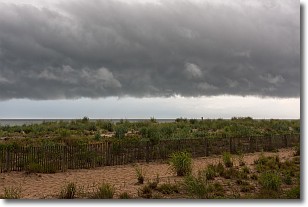
Weather Topic: What are Shelf Clouds?
Home - Education - Cloud Types - Shelf Clouds
 Next Topic: Sleet
A shelf cloud is similar to a wall cloud, but forms at the front
of a storm cloud, instead of at the rear, where wall clouds form.
A shelf cloud is caused by a series of events set into motion by the advancing
storm; first, cool air settles along the ground where precipitation has just fallen.
As the cool air is brought in, the warmer air is displaced, and rises above it,
because it is less dense. When the warmer air reaches the bottom of the storm cloud,
it begins to cool again, and the resulting condensation is a visible shelf cloud.
Next Topic: Sleet
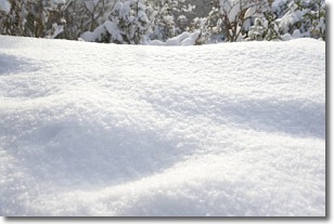
Weather Topic: What is Snow?
Home - Education - Precipitation - Snow
 Next Topic: Stratocumulus Clouds
Snow is precipitation taking the form of ice crystals. Each ice crystal, or snowflake,
has unique characteristics, but all of them grow in a hexagonal structure.
Snowfall can last for sustained periods of time and result in significant buildup
of snow on the ground.
On the earth's surface, snow starts out light and powdery, but as it begins to melt
it tends to become more granular, producing small bits of ice which have the consistency of
sand. After several cycles of melting and freezing, snow can become very dense
and ice-like, commonly known as snow pack.
Next Topic: Stratocumulus Clouds
Current conditions powered by WeatherAPI.com


