Weather Alert in California
Winter Storm Watch issued February 13 at 7:52PM PST until February 18 at 10:00PM PST by NWS Hanford CA
AREAS AFFECTED: Mariposa-Madera Lower Sierra; Fresno-Tulare Lower Sierra; South End of the Lower Sierra; Yosemite NP outside of the valley; Yosemite Valley; San Joaquin River Canyon; Upper San Joaquin River; Kaiser to Rodgers Ridge; Kings Canyon NP; Grant Grove Area; Sequoia NP; South End of the Upper Sierra; Piute Walker Basin
DESCRIPTION: * WHAT...Heavy snow with total snow accumulations 3 to 5 feet above 6,000 feet with 5 to 7 feet over the highest elevations and 1 to 2 feet down to 4,000 feet. Winds could gust as high as 60 mph. * WHERE...A portion of central California. * WHEN...From Sunday evening through Wednesday evening. * IMPACTS...Travel could be very difficult to impossible. The hazardous conditions could impact the Monday morning and evening commutes. Strong winds could cause tree damage. * ADDITIONAL DETAILS...Snow levels will begin at 5,500 to 6,000 feet on Sunday night and lower to 4,000 feet Tuesday morning. Light snow accumulations down to 3,000 feet Tuesday night into Wednesday.
INSTRUCTION: Monitor the latest forecasts for updates on this situation.
Want more detail? Get the Complete 7 Day and Night Detailed Forecast!
Current U.S. National Radar--Current
The Current National Weather Radar is shown below with a UTC Time (subtract 5 hours from UTC to get Eastern Time).

National Weather Forecast--Current
The Current National Weather Forecast and National Weather Map are shown below.

National Weather Forecast for Tomorrow
Tomorrow National Weather Forecast and Tomorrow National Weather Map are show below.

North America Water Vapor (Moisture)
This map shows recent moisture content over North America. Bright and colored areas show high moisture (ie, clouds); brown indicates very little moisture present; black indicates no moisture.

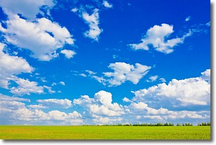
Weather Topic: What are Cumulus Clouds?
Home - Education - Cloud Types - Cumulus Clouds
 Next Topic: Drizzle
Cumulus clouds are fluffy and textured with rounded tops, and
may have flat bottoms. The border of a cumulus cloud
is clearly defined, and can have the appearance of cotton or cauliflower.
Cumulus clouds form at low altitudes (rarely above 2 km) but can grow very tall,
becoming cumulus congestus and possibly the even taller cumulonimbus clouds.
When cumulus clouds become taller, they have a greater chance of producing precipitation.
Next Topic: Drizzle
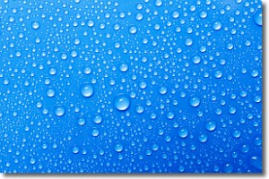
Weather Topic: What is Evaporation?
Home - Education - Precipitation - Evaporation
 Next Topic: Fog
Evaporation is the process which returns water from the earth
back to the atmosphere, and is another crucial process in the water cycle.
Evaporation is the transformation of liquid into gas, and it happens because
molecules are excited by the application of energy and turn into vapor.
In order for water to evaporate it has to be on the surface of a body of water.
Next Topic: Fog
Current conditions powered by WeatherAPI.com


