Weather Alert in Colorado
Red Flag Warning issued March 26 at 1:40PM MDT until March 26 at 8:00PM MDT by NWS Pueblo CO
AREAS AFFECTED: Upper Arkansas River Valley Including Lake County and Chaffee County; Fremont County Including Canon City/Howard/Texas Creek; San Luis Valley Including Alamosa/Del Norte/Fort Garland/Saguache; Southern Front Range Including Sangre De Cristo Mountains/Wet Mountains/La Veta Pass; Huerfano County Including Walsenburg; Western Las Animas County Including Trinidad and Thatcher; Eastern Las Animas County Including Pinon Canyon; Baca County Including Springfield and Eastern Comanche Grasslands
DESCRIPTION: ...FIRE WEATHER WATCH IN EFFECT FROM SATURDAY AFTERNOON THROUGH SATURDAY EVENING FOR FIRE WEATHER ZONES 220, 222, 224, 225, 229, 230, 233, AND 237... The National Weather Service in Pueblo has issued a Fire Weather Watch for gusty winds and low relative humidity, which is in effect from Saturday afternoon through Saturday evening. * AFFECTED AREA...Fire Weather Zones 220, 222, 224, 225, 229, 230, 233 and 237. * TIMING...For the Red Flag Warning, until 8 PM MDT this evening. For the Fire Weather Watch, from Saturday afternoon through Saturday evening. * WINDS...For the Red Flag Warning, west-northwest 15 to 25 with gusts to 45 mph. For the Fire Weather Watch, south-southwest 15-25 mph with gusts to 35 mph. * RELATIVE HUMIDITY...As low as 7 percent. * IMPACTS...Elevated fire danger is expected. Fires will catch and spread rapidly and erratically.
INSTRUCTION: A Red Flag Warning means that critical fire weather conditions are either occurring now, or will shortly. A combination of strong winds, low relative humidity, and warm temperatures can contribute to extreme fire behavior. A Fire Weather Watch means that critical fire weather conditions are forecast to occur. Listen for later forecasts and possible Red Flag Warnings.
Want more detail? Get the Complete 7 Day and Night Detailed Forecast!
Current U.S. National Radar--Current
The Current National Weather Radar is shown below with a UTC Time (subtract 5 hours from UTC to get Eastern Time).

National Weather Forecast--Current
The Current National Weather Forecast and National Weather Map are shown below.

National Weather Forecast for Tomorrow
Tomorrow National Weather Forecast and Tomorrow National Weather Map are show below.

North America Water Vapor (Moisture)
This map shows recent moisture content over North America. Bright and colored areas show high moisture (ie, clouds); brown indicates very little moisture present; black indicates no moisture.

Weather Topic: What are Fractus Clouds?
Home - Education - Cloud Types - Fractus Clouds
 Next Topic: Freezing Rain
A fractus cloud (scud) is a fragmented, tattered cloud which has
likely been sheared off of another cloud. They are accessory clouds, meaning they
develop from parent clouds, and are named in a way which describes the original
cloud which contained them.
Fractus clouds which have originated from cumulus clouds are referred to as
cumulus fractus, while fractus clouds which have originated from stratus clouds
are referred to as stratus fractus. Under certain conditions a fractus cloud might
merge with another cloud, or develop into a cumulus cloud, but usually a
fractus cloud seen by itself will dissipate rapidly.
They are often observed on the leading and trailing edges of storm clouds,
and are a display of wind activity.
Next Topic: Freezing Rain
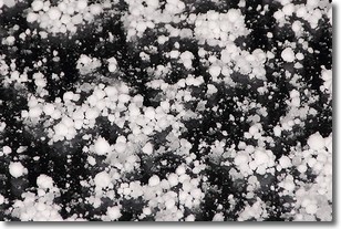
Weather Topic: What is Graupel?
Home - Education - Precipitation - Graupel
 Next Topic: Hail
Graupel is a form of precipitation that is created by atmospheric conditions
which cause supercooled water droplets to contact snow crystals and freeze to
their surface.
Sometimes known as soft hail or snow pellets, graupel is delicate and easily
destroyed by touch. Whereas hail usually falls during severe weather, graupel
doesn't require such conditions to form, and can form in mild precipitation
similar to situations which produce snowfall.
Next Topic: Hail
Current conditions powered by WeatherAPI.com


