Weather Alert in California
Avalanche Watch issued February 15 at 7:36AM PST by NWS Las Vegas NV
AREAS AFFECTED: Eastern Sierra Slopes of Inyo County
DESCRIPTION: AVAVEF The Eastern Sierra Avalanche Center in Mammoth Lakes has issued a Backcountry Avalanche Watch for the following areas: the Eastern Sierra in Mono County and the Eastern Sierra in Inyo County * WHAT...The avalanche danger is expected to rise to HIGH by tomorrow afternoon and remain elevated into mid-week. * WHERE...The eastern slopes of the Sierra Nevada mountain range between Virgina Lakes on the north to Bishop Creek on the south. * WHEN...In effect from Sun 07:00 PST to Mon 07:00 PST. * IMPACTS...|Heavy snow and extreme winds will create widespread areas of unstable snow.
INSTRUCTION: Very dangerous avalanche conditions are expected to develop. Avalanches may run long distances, and can run into mature forests, valley floors or flat terrain. Travel in avalanche terrain is not recommended. Consult http://www.esavalanche.org or www.avalanche.org for more detailed information Similar avalanche danger may exist at locations outside the coverage area of this or any avalanche center.
Want more detail? Get the Complete 7 Day and Night Detailed Forecast!
Current U.S. National Radar--Current
The Current National Weather Radar is shown below with a UTC Time (subtract 5 hours from UTC to get Eastern Time).

National Weather Forecast--Current
The Current National Weather Forecast and National Weather Map are shown below.

National Weather Forecast for Tomorrow
Tomorrow National Weather Forecast and Tomorrow National Weather Map are show below.

North America Water Vapor (Moisture)
This map shows recent moisture content over North America. Bright and colored areas show high moisture (ie, clouds); brown indicates very little moisture present; black indicates no moisture.

Weather Topic: What are Cirrus Clouds?
Home - Education - Cloud Types - Cirrus Clouds
 Next Topic: Condensation
Cirrus clouds are high-level clouds that occur above 20,000 feet
and are composed mainly of ice crystals.
They are thin and wispy in appearance.
What do they indicate?
They are often the first sign of an approaching storm.
Next Topic: Condensation
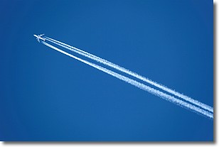
Weather Topic: What are Contrails?
Home - Education - Cloud Types - Contrails
 Next Topic: Cumulonimbus Clouds
A contrail is an artificial cloud, created by the passing of an
aircraft.
Contrails form because water vapor in the exhaust of aircraft engines is suspended
in the air under certain temperatures and humidity conditions. These contrails
are called exhaust contrails.
Another type of contrail can form due to a temporary reduction in air pressure
moving over the plane's surface, causing condensation.
These are called aerodynamic contrails.
When you can see your breath on a cold day, it is also because of condensation.
The reason contrails last longer than the condensation from your breath is
because the water in contrails freezes into ice particles.
Next Topic: Cumulonimbus Clouds
Current conditions powered by WeatherAPI.com


