Weather Alert in Colorado
Flash Flood Warning issued June 17 at 11:40AM MDT until June 17 at 2:15PM MDT by NWS Denver CO
AREAS AFFECTED: Larimer, CO
DESCRIPTION: FFWBOU The National Weather Service in Denver has issued a * Flash Flood Warning for... Central Larimer County in north central Colorado... * Until 215 PM MDT. * At 1140 AM MDT, Doppler radar indicated thunderstorms producing heavy rain near Pennock Pass, or 21 miles west of Fort Collins, moving east at 10 mph. Between 0.5 and 1 inch of rain has fallen. Additional rainfall amounts of 0.5 to 1 inch are possible in the warned area. Flash flooding is ongoing or expected to begin shortly. The storm producing the flooding is over rural areas of Central Larimer County, moving east at 10 miles per hour. HAZARD...Life threatening flash flooding. Thunderstorms producing flash flooding on the Cameron Peak burn scar. SOURCE...Radar indicated. IMPACT...Life threatening flash flooding of creeks and streams, roads, and low lying areas. * Some locations that will experience flash flooding include... Pennock Pass and Glen Haven.
INSTRUCTION: Move to higher ground now. Act quickly to protect your life. THIS IS A LIFE THREATENING SITUATION! Heavy Rainfall will cause extensive and severe flooding of creeks, streams, roads and culverts in the affected part of the Cameron Peak burn area. Rock slides or debris flows can also be expected across roads in the warning area.
Want more detail? Get the Complete 7 Day and Night Detailed Forecast!
Current U.S. National Radar--Current
The Current National Weather Radar is shown below with a UTC Time (subtract 5 hours from UTC to get Eastern Time).

National Weather Forecast--Current
The Current National Weather Forecast and National Weather Map are shown below.

National Weather Forecast for Tomorrow
Tomorrow National Weather Forecast and Tomorrow National Weather Map are show below.

North America Water Vapor (Moisture)
This map shows recent moisture content over North America. Bright and colored areas show high moisture (ie, clouds); brown indicates very little moisture present; black indicates no moisture.

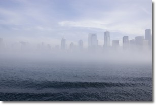
Weather Topic: What is Fog?
Home - Education - Cloud Types - Fog
 Next Topic: Fractus Clouds
Fog is technically a type of stratus cloud, which lies along the
ground and obscures visibility.
It is usually created when humidity in the air condenses into tiny water droplets.
Because of this, some places are more prone to foggy weather, such as regions
close to a body of water.
Fog is similar to mist; both are the appearance of water droplets suspended in
the air, but fog is the term applied to the condition when visibility is less than 1 km.
Next Topic: Fractus Clouds
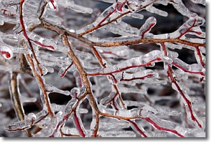
Weather Topic: What is Freezing Rain?
Home - Education - Precipitation - Freezing Rain
 Next Topic: Graupel
Freezing rain is a condition where precipitation which has fallen in the form of
water droplets reaches temperatures which are below freezing and freezes upon
coming into contact
with surface objects. The result of this precipitation is a glaze of ice which
can be damaging to plants and man-made structures. A severe onset of freezing
rain which results in a very thick glaze of ice is known as an ice storm.
Next Topic: Graupel
Current conditions powered by WeatherAPI.com


