Weather Alert in Colorado
Fire Weather Watch issued February 14 at 3:05AM MST until February 16 at 6:00PM MST by NWS Pueblo CO
AREAS AFFECTED: Northern El Paso County Including Monument and Black Forest; Southern El Paso County Including Fort Carson and Colorado Springs; Pueblo County Including Pueblo; Huerfano County Including Walsenburg; Western Las Animas County Including Trinidad and Thatcher
DESCRIPTION: ...FIRE WEATHER WATCH REMAINS IN EFFECT FROM TUESDAY MORNING THROUGH TUESDAY EVENING FOR STRONG WINDS AND LOW RELATIVE HUMIDITY FOR FIRE WEATHER ZONES 226, 227, 228, 229, AND 230... * AFFECTED AREA...Fire Weather Zones 226, 227, 228, 229 and 230. * TIMING...For the first Fire Weather Watch, from Monday morning through Monday afternoon. For the second Fire Weather Watch, from Tuesday morning through Tuesday evening. * WINDS...Southwest 30 to 40 mph with gusts up to 60 mph. * RELATIVE HUMIDITY...As low as 11 percent. * IMPACTS...Elevated fire danger is expected. Fires will catch and spread rapidly and erratically.
INSTRUCTION: A Fire Weather Watch means that critical fire weather conditions are forecast to occur. Listen for later forecasts and possible Red Flag Warnings.
Want more detail? Get the Complete 7 Day and Night Detailed Forecast!
Current U.S. National Radar--Current
The Current National Weather Radar is shown below with a UTC Time (subtract 5 hours from UTC to get Eastern Time).

National Weather Forecast--Current
The Current National Weather Forecast and National Weather Map are shown below.

National Weather Forecast for Tomorrow
Tomorrow National Weather Forecast and Tomorrow National Weather Map are show below.

North America Water Vapor (Moisture)
This map shows recent moisture content over North America. Bright and colored areas show high moisture (ie, clouds); brown indicates very little moisture present; black indicates no moisture.

Weather Topic: What is Freezing Rain?
Home - Education - Precipitation - Freezing Rain
 Next Topic: Graupel
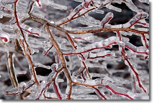
Freezing rain is a condition where precipitation which has fallen in the form of
water droplets reaches temperatures which are below freezing and freezes upon
coming into contact
with surface objects. The result of this precipitation is a glaze of ice which
can be damaging to plants and man-made structures. A severe onset of freezing
rain which results in a very thick glaze of ice is known as an ice storm.
Next Topic: Graupel
Weather Topic: What is Hail?
Home - Education - Precipitation - Hail
 Next Topic: Hole Punch Clouds
Hail is a form of precipitation which is recognized by large solid balls or
clumps of ice. Hail is created by thunderstorm clouds with strong updrafts of wind.
As the hailstones remain in the updraft, ice is deposited onto them until their
weight becomes heavy enough for them to fall to the earth's surface.
Hail storms can cause significant damage to crops, aircrafts, and man-made structures,
despite the fact that the duration is usually less than ten minutes.
Next Topic: Hole Punch Clouds
Current conditions powered by WeatherAPI.com


