Weather Alert in California
Flood Watch issued February 18 at 2:54AM PST until February 18 at 6:00AM PST by NWS Los Angeles/Oxnard CA
AREAS AFFECTED: Santa Clarita Valley; Ventura County Beaches; Ventura County Inland Coast; Lake Casitas; Ojai Valley; Central Ventura County Valleys; Malibu Coast; Los Angeles County Beaches; Palos Verdes Hills; Los Angeles County Inland Coast including Downtown Los Angeles; Western Santa Monica Mountains Recreational Area; Eastern Santa Monica Mountains Recreational Area; Calabasas and Agoura Hills; Western San Fernando Valley; Eastern San Fernando Valley; Southeastern Ventura County Valleys; Santa Susana Mountains; Southern Ventura County Mountains; Northern Ventura County Mountains; Interstate 5 Corridor; Western San Gabriel Mountains and Highway 14 Corridor; Eastern San Gabriel Mountains; Western Antelope Valley Foothills; Eastern Antelope Valley Foothills; Antelope Valley; Los Angeles County San Gabriel Valley
DESCRIPTION: * WHAT...Flooding caused by excessive rainfall is possible. Rock and mud slides are possible near steep terrain and along canyon roads. Debris flows are possible on recent burn scars. * WHERE...A portion of southwest California, including the following areas, Antelope Valley, Calabasas and Agoura Hills, Central Ventura County Valleys, Eastern Antelope Valley Foothills, Eastern San Fernando Valley, Eastern San Gabriel Mountains, Eastern Santa Monica Mountains Recreational Area, Interstate 5 Corridor, Lake Casitas, Los Angeles County Beaches, Los Angeles County Inland Coast including Downtown Los Angeles, Los Angeles County San Gabriel Valley, Malibu Coast, Northern Ventura County Mountains, Ojai Valley, Palos Verdes Hills, Santa Clarita Valley, Santa Susana Mountains, Southeastern Ventura County Valleys, Southern Ventura County Mountains, Ventura County Beaches, Ventura County Inland Coast, Western Antelope Valley Foothills, Western San Fernando Valley, Western San Gabriel Mountains and Highway 14 Corridor and Western Santa Monica Mountains Recreational Area. * WHEN...Until 6 AM PST early this morning. * IMPACTS...Flash flooding is possible. Excessive runoff may result in flooding of low-lying and flood-prone locations, including creeks and streams. Flooding may occur in poor drainage and urban areas. Low-water crossings may be flooded. Extensive street flooding is possible. * ADDITIONAL DETAILS... - http://www.weather.gov/safety/flood
INSTRUCTION: You should monitor later forecasts and be alert for possible Flood Warnings. Those living in areas prone to flooding and recent burn scars should be prepared to take action should flooding develop. Travel through passes and canyons could become dangerous, and be alert for rock slides and mud slides. Follow the direction of Emergency Management and Law Enforcement officials.
Want more detail? Get the Complete 7 Day and Night Detailed Forecast!
Current U.S. National Radar--Current
The Current National Weather Radar is shown below with a UTC Time (subtract 5 hours from UTC to get Eastern Time).

National Weather Forecast--Current
The Current National Weather Forecast and National Weather Map are shown below.

National Weather Forecast for Tomorrow
Tomorrow National Weather Forecast and Tomorrow National Weather Map are show below.

North America Water Vapor (Moisture)
This map shows recent moisture content over North America. Bright and colored areas show high moisture (ie, clouds); brown indicates very little moisture present; black indicates no moisture.

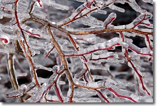
Weather Topic: What is Freezing Rain?
Home - Education - Precipitation - Freezing Rain
 Next Topic: Graupel
Freezing rain is a condition where precipitation which has fallen in the form of
water droplets reaches temperatures which are below freezing and freezes upon
coming into contact
with surface objects. The result of this precipitation is a glaze of ice which
can be damaging to plants and man-made structures. A severe onset of freezing
rain which results in a very thick glaze of ice is known as an ice storm.
Next Topic: Graupel
Weather Topic: What is Hail?
Home - Education - Precipitation - Hail
 Next Topic: Hole Punch Clouds
Hail is a form of precipitation which is recognized by large solid balls or
clumps of ice. Hail is created by thunderstorm clouds with strong updrafts of wind.
As the hailstones remain in the updraft, ice is deposited onto them until their
weight becomes heavy enough for them to fall to the earth's surface.
Hail storms can cause significant damage to crops, aircrafts, and man-made structures,
despite the fact that the duration is usually less than ten minutes.
Next Topic: Hole Punch Clouds
Current conditions powered by WeatherAPI.com


