Weather Alert in Maine
Special Weather Statement issued August 22 at 8:39AM EDT by NWS Gray ME
AREAS AFFECTED: Interior York; Central Interior Cumberland; Androscoggin; Kennebec; Interior Waldo; Coastal York; Coastal Cumberland; Sagadahoc; Lincoln; Knox; Coastal Waldo; Interior Cumberland Highlands; Strafford; Eastern Hillsborough; Interior Rockingham; Coastal Rockingham
DESCRIPTION: A very dry air mass and breezy conditions will combine with dead and dry fuels such as grass, leaves, and twigs to create the potential for uncontrolled fire spread across the coastal plain of Maine and southeast New Hampshire today. This afternoon, relative humidity values will decrease to low levels between 25 to 30 R.H. %. At the same time, north to northeast| winds between 10 to 15 mph with frequent gusts to 20 mph will continue to dry fuels and increase fire spread potential. Near the coast, a sea breeze will develop this afternoon with southeast winds gusting to 20 mph. Wind gusts are expected to diminish later this evening with increasing relative humidity values. Extra caution should be taken to prevent wildfires. Always consult with fire officials before engaging in any open burning activities and comply with all applicable laws and regulations. Never leave an open fire unattended and always extinguish campfires completely before leaving.
INSTRUCTION: N/A
Want more detail? Get the Complete 7 Day and Night Detailed Forecast!
Current U.S. National Radar--Current
The Current National Weather Radar is shown below with a UTC Time (subtract 5 hours from UTC to get Eastern Time).

National Weather Forecast--Current
The Current National Weather Forecast and National Weather Map are shown below.

National Weather Forecast for Tomorrow
Tomorrow National Weather Forecast and Tomorrow National Weather Map are show below.

North America Water Vapor (Moisture)
This map shows recent moisture content over North America. Bright and colored areas show high moisture (ie, clouds); brown indicates very little moisture present; black indicates no moisture.

Weather Topic: What is Graupel?
Home - Education - Precipitation - Graupel
 Next Topic: Hail
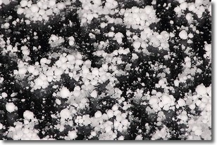
Graupel is a form of precipitation that is created by atmospheric conditions
which cause supercooled water droplets to contact snow crystals and freeze to
their surface.
Sometimes known as soft hail or snow pellets, graupel is delicate and easily
destroyed by touch. Whereas hail usually falls during severe weather, graupel
doesn't require such conditions to form, and can form in mild precipitation
similar to situations which produce snowfall.
Next Topic: Hail
Weather Topic: What are Hole Punch Clouds?
Home - Education - Cloud Types - Hole Punch Clouds
 Next Topic: Mammatus Clouds
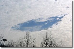
A hole punch cloud is an unusual occurrence when a disk-shaped
hole appears in a cirrostratus, cirrocumulus, or altocumulus cloud.
When part of the cloud forms ice crystals, water droplets in the surrounding area
of the cloud evaporate. The effect of this process produces a large elliptical
gap in the cloud. The hole punch cloud formation is rare, but it is not specific
to any geographic area.
Other names which have been used to describe this phenomena include fallstreak hole,
skypunch, and cloud hole.
Next Topic: Mammatus Clouds
Current conditions powered by WeatherAPI.com


