Weather Alert in Minnesota
Winter Storm Warning issued February 16 at 10:17PM CST until February 19 at 12:00PM CST by NWS Duluth MN
AREAS AFFECTED: Northern Cook/Northern Lake
DESCRIPTION: * WHAT...Heavy snow expected. Total snow accumulations between 4 and 8 inches except between 10 and 15 inches for the higher terrain of the North Shore. Winds gusting as high as 50 mph. * WHERE...Northern Cook and Lake County. This also includes the Boundary Waters eastern and central area. * WHEN...From 9 PM Tuesday to noon CST Thursday. * IMPACTS...Near whiteout conditions are possible as visibilities may drop to around 1/4 mile due to falling and blowing snow. * ADDITIONAL DETAILS...Expect terrain enhancement to snowfall totals and snowfall rates along the North Shore terrain ridge parts of central Lake County. The heaviest snowfall rates will be Tuesday night and Wednesday morning.
INSTRUCTION: If you must travel, keep an extra flashlight, food, and water in your vehicle in case of an emergency. Call 511 or visit www.511mn.org for Minnesota road information.
Want more detail? Get the Complete 7 Day and Night Detailed Forecast!
Current U.S. National Radar--Current
The Current National Weather Radar is shown below with a UTC Time (subtract 5 hours from UTC to get Eastern Time).

National Weather Forecast--Current
The Current National Weather Forecast and National Weather Map are shown below.

National Weather Forecast for Tomorrow
Tomorrow National Weather Forecast and Tomorrow National Weather Map are show below.

North America Water Vapor (Moisture)
This map shows recent moisture content over North America. Bright and colored areas show high moisture (ie, clouds); brown indicates very little moisture present; black indicates no moisture.

Weather Topic: What are Cirrus Clouds?
Home - Education - Cloud Types - Cirrus Clouds
 Next Topic: Condensation
Cirrus clouds are high-level clouds that occur above 20,000 feet
and are composed mainly of ice crystals.
They are thin and wispy in appearance.
What do they indicate?
They are often the first sign of an approaching storm.
Next Topic: Condensation
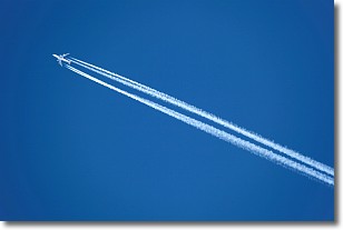
Weather Topic: What are Contrails?
Home - Education - Cloud Types - Contrails
 Next Topic: Cumulonimbus Clouds
A contrail is an artificial cloud, created by the passing of an
aircraft.
Contrails form because water vapor in the exhaust of aircraft engines is suspended
in the air under certain temperatures and humidity conditions. These contrails
are called exhaust contrails.
Another type of contrail can form due to a temporary reduction in air pressure
moving over the plane's surface, causing condensation.
These are called aerodynamic contrails.
When you can see your breath on a cold day, it is also because of condensation.
The reason contrails last longer than the condensation from your breath is
because the water in contrails freezes into ice particles.
Next Topic: Cumulonimbus Clouds
Current conditions powered by WeatherAPI.com


