Weather Alert in Montana
Wind Advisory issued February 23 at 10:52PM MST until February 24 at 11:00AM MST by NWS Billings MT
AREAS AFFECTED: Livingston Area; Beartooth Foothills
DESCRIPTION: * WHAT...For the Wind Advisory, west winds 30 to 40 mph with gusts up to 65 mph occurring. For the High Wind Watch, west winds 35 to 45 mph with gusts up to 75 mph possible. * WHERE...Beartooth Foothills and Livingston Area. * WHEN...For the Wind Advisory, until 11 AM MST Tuesday. For the High Wind Watch, from late Tuesday night through Friday morning. * IMPACTS...Strong crosswinds will make travel difficult along Interstate 90 from Livingston to Big Timber and roads along the Beartooth Foothills. * ADDITIONAL DETAILS...Winds will begin to decrease with the passage of a cold front early Tuesday morning. Periods of strong winds are expected to develop again Wednesday and Thursday.
INSTRUCTION: Winds this strong can make driving difficult, especially for high profile vehicles. Use extra caution and consider postponing travel until winds subside, or take an alternate route. Secure loose outdoor items.
Want more detail? Get the Complete 7 Day and Night Detailed Forecast!
Current U.S. National Radar--Current
The Current National Weather Radar is shown below with a UTC Time (subtract 5 hours from UTC to get Eastern Time).

National Weather Forecast--Current
The Current National Weather Forecast and National Weather Map are shown below.

National Weather Forecast for Tomorrow
Tomorrow National Weather Forecast and Tomorrow National Weather Map are show below.

North America Water Vapor (Moisture)
This map shows recent moisture content over North America. Bright and colored areas show high moisture (ie, clouds); brown indicates very little moisture present; black indicates no moisture.

Weather Topic: What is Freezing Rain?
Home - Education - Precipitation - Freezing Rain
 Next Topic: Graupel
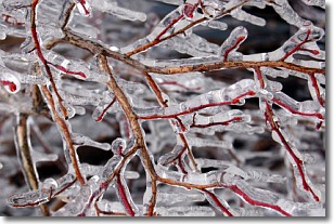
Freezing rain is a condition where precipitation which has fallen in the form of
water droplets reaches temperatures which are below freezing and freezes upon
coming into contact
with surface objects. The result of this precipitation is a glaze of ice which
can be damaging to plants and man-made structures. A severe onset of freezing
rain which results in a very thick glaze of ice is known as an ice storm.
Next Topic: Graupel
Weather Topic: What is Hail?
Home - Education - Precipitation - Hail
 Next Topic: Hole Punch Clouds
Hail is a form of precipitation which is recognized by large solid balls or
clumps of ice. Hail is created by thunderstorm clouds with strong updrafts of wind.
As the hailstones remain in the updraft, ice is deposited onto them until their
weight becomes heavy enough for them to fall to the earth's surface.
Hail storms can cause significant damage to crops, aircrafts, and man-made structures,
despite the fact that the duration is usually less than ten minutes.
Next Topic: Hole Punch Clouds
Current conditions powered by WeatherAPI.com


