Weather Alert in Colorado
Fire Weather Watch issued February 14 at 2:13AM MST until February 17 at 8:00PM MST by NWS Goodland KS
AREAS AFFECTED: Yuma; Kit Carson County
DESCRIPTION: For Sunday, southwest winds of 15-20 mph are forecast to begin around 8-9 am Mountain time across Yuma and Kit Carson county before expanding east into the remainder of the Fire Weather Watch through the afternoon. For Tuesday, low relative humidity and sustained winds around 40 mph could lead to explosive fire growth for fires that ignite. Southwest winds could change to west behind a cold front in the afternoon. * AFFECTED AREA...Fire Weather Zones 252 Yuma and 253 Kit Carson. * TIMING...For the first Fire Weather Watch, from Sunday morning through Sunday afternoon. For the second Fire Weather Watch, from Tuesday morning through Tuesday evening. * WINDS...For Sunday, southwest winds of 15-20 mph gusting to 35 mph. For Tuesday, southwest 35 to 45 mph with gusts up to 65 mph. * RELATIVE HUMIDITY...Around 11 percent. * IMPACTS...Dangerous and unpredictable fire behavior. Any fires that develop may rapidly grow and spread out of control.
INSTRUCTION: A Fire Weather Watch means that critical fire weather conditions are forecast to occur. Listen for later forecasts and possible red flag warnings.
Want more detail? Get the Complete 7 Day and Night Detailed Forecast!
Current U.S. National Radar--Current
The Current National Weather Radar is shown below with a UTC Time (subtract 5 hours from UTC to get Eastern Time).

National Weather Forecast--Current
The Current National Weather Forecast and National Weather Map are shown below.

National Weather Forecast for Tomorrow
Tomorrow National Weather Forecast and Tomorrow National Weather Map are show below.

North America Water Vapor (Moisture)
This map shows recent moisture content over North America. Bright and colored areas show high moisture (ie, clouds); brown indicates very little moisture present; black indicates no moisture.

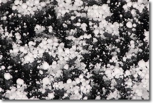
Weather Topic: What is Graupel?
Home - Education - Precipitation - Graupel
 Next Topic: Hail
Graupel is a form of precipitation that is created by atmospheric conditions
which cause supercooled water droplets to contact snow crystals and freeze to
their surface.
Sometimes known as soft hail or snow pellets, graupel is delicate and easily
destroyed by touch. Whereas hail usually falls during severe weather, graupel
doesn't require such conditions to form, and can form in mild precipitation
similar to situations which produce snowfall.
Next Topic: Hail
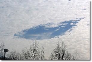
Weather Topic: What are Hole Punch Clouds?
Home - Education - Cloud Types - Hole Punch Clouds
 Next Topic: Mammatus Clouds
A hole punch cloud is an unusual occurrence when a disk-shaped
hole appears in a cirrostratus, cirrocumulus, or altocumulus cloud.
When part of the cloud forms ice crystals, water droplets in the surrounding area
of the cloud evaporate. The effect of this process produces a large elliptical
gap in the cloud. The hole punch cloud formation is rare, but it is not specific
to any geographic area.
Other names which have been used to describe this phenomena include fallstreak hole,
skypunch, and cloud hole.
Next Topic: Mammatus Clouds
Current conditions powered by WeatherAPI.com


