Weather Alert in Kansas
Fire Weather Watch issued February 14 at 2:13AM MST until February 17 at 8:00PM MST by NWS Goodland KS
AREAS AFFECTED: Cheyenne; Rawlins; Sherman; Dundy; Hitchcock; Red Willow
DESCRIPTION: For Sunday, southwest winds of 15-20 mph are forecast to begin around 8-9 am Mountain time across Yuma and Kit Carson county before expanding east into the remainder of the Fire Weather Watch through the afternoon. For Tuesday, low relative humidity and sustained winds around 40 mph could lead to explosive fire growth for fires that ignite. Southwest winds could change to west behind a cold front in the afternoon. The National Weather Service in Goodland has issued a Fire Weather Watch for wind and low relative humidity, which is in effect from Tuesday morning through Tuesday evening. * AFFECTED AREA...Fire Weather Zones 001 Cheyenne, 002 Rawlins, 013 Sherman, 079 Dundy, 080 Hitchcock and 081 Red Willow. * TIMING...For the first Fire Weather Watch, from Sunday morning through Sunday afternoon. For the second Fire Weather Watch, from Tuesday morning through Tuesday evening. * WINDS...For Sunday, southwest winds of 10-20 mph gusting to 30 mph. For Tuesday, southwest 20 to 30 mph with gusts up to 45 mph. * RELATIVE HUMIDITY...Around 12 percent. * IMPACTS...Unpredictable fire behavior. Any fires that develop may rapidly grow and spread out of control.
INSTRUCTION: A Fire Weather Watch means that critical fire weather conditions are forecast to occur. Listen for later forecasts and possible red flag warnings.
Want more detail? Get the Complete 7 Day and Night Detailed Forecast!
Current U.S. National Radar--Current
The Current National Weather Radar is shown below with a UTC Time (subtract 5 hours from UTC to get Eastern Time).

National Weather Forecast--Current
The Current National Weather Forecast and National Weather Map are shown below.

National Weather Forecast for Tomorrow
Tomorrow National Weather Forecast and Tomorrow National Weather Map are show below.

North America Water Vapor (Moisture)
This map shows recent moisture content over North America. Bright and colored areas show high moisture (ie, clouds); brown indicates very little moisture present; black indicates no moisture.

Weather Topic: What are Cirrostratus Clouds?
Home - Education - Cloud Types - Cirrostratus Clouds
 Next Topic: Cirrus Clouds
Cirrostratus clouds are high, thin clouds that form above
20,000 feet and are made mostly of ice crystals. They sometimes look like giant
feathers, horse tails, or curls of hair in the sky.
These clouds are pushed by the jet stream and can move at high speeds reaching
100 mph.
What do they indicate?
They indicate that a precipitation is likely within 24 hours.
Next Topic: Cirrus Clouds
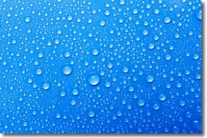
Weather Topic: What is Condensation?
Home - Education - Precipitation - Condensation
 Next Topic: Contrails
Condensation is the process which creates clouds, and therefore
it is a crucial process in the water cycle.
Condensation is the change of matter from a state of gas into a state of liquid,
and it happens because water molecules release heat into the atmosphere and
become organized into a more closely packed structure, what we might see as
water droplets.
Water is always present in the air around us as a vapor, but it's too small for
us to see. When water undergoes the process of condensation it becomes organized
into visible water droplets. You've probably seen condensation happen before on the
surface of a cold drink!
Next Topic: Contrails
Current conditions powered by WeatherAPI.com


