Weather Alert in Idaho
Avalanche Watch issued February 22 at 10:36PM PST by NWS Spokane WA
AREAS AFFECTED: Bonner, ID; Boundary, ID; Shoshone, ID
DESCRIPTION: AVAOTX The following message is transmitted at the request of the Idaho Panhandle Avalanche Center. ...AVALANCHE WATCH ISSUED BY THE IDAHO PANHANDLE AVALANCHE CENTER... 19:00 PST Sun Feb 22 2026 The Idaho Panhandle Avalanche Center in Sandpoint has issued a BACKCOUNTRY AVALANCHE WATCH for the following areas: NWS Missoula MT - MTZ001 (MTZ001) NWS Spokane WA - ID 017 (Bonner County)...ID 021 (Boundary County)...ID 079 (Shoshone County) * WHAT...An Avalanche Watch is in effect from Sunday 7 PM PST to Monday 4 PM PST. Very dangerous avalanche conditions are likely to develop by Monday afternoon and raise the danger to High (Level 4of5). * WHERE...The Selkirk, West and East Cabinet, Purcell, and Bitterroot Mountains - Silver Valley above 4,000 feet. * WHEN...In effect from Sun 19:00 PST to Mon 16:00 PST. * IMPACTS...A warm, wet storm will deliver moderate to heavy snowfall to the snowpack. The new snowfall may add enough weight to the snowpack to overload fragile weak snow layers and cause a widespread cycle of avalanches large enough to bury, injure, or kill a person. Some of these avalanches could release naturally, propagate widely across terrain features like ridges, and run long distances into mature forests, valley floors, or flat terrain. It will become very easy for backcountry travelers to trigger them. * PRECAUTIONARY / PREPAREDNESS ACTIONS...Travel in or below avalanche terrain is not recommended during this period. Consult http://www.idahopanhandleavalanche.org/ or www.avalanche.org for more detailed information. Similar avalanche danger may exist at locations outside the coverage area of this or any avalanche center.
INSTRUCTION: N/A
Want more detail? Get the Complete 7 Day and Night Detailed Forecast!
Current U.S. National Radar--Current
The Current National Weather Radar is shown below with a UTC Time (subtract 5 hours from UTC to get Eastern Time).

National Weather Forecast--Current
The Current National Weather Forecast and National Weather Map are shown below.

National Weather Forecast for Tomorrow
Tomorrow National Weather Forecast and Tomorrow National Weather Map are show below.

North America Water Vapor (Moisture)
This map shows recent moisture content over North America. Bright and colored areas show high moisture (ie, clouds); brown indicates very little moisture present; black indicates no moisture.

Weather Topic: What are Nimbostratus Clouds?
Home - Education - Cloud Types - Nimbostratus Clouds
 Next Topic: Precipitation
A nimbostratus cloud is similar to a stratus cloud in its formless,
smooth appearance. However, a nimbostratus cloud is darker than a stratus cloud,
because it is thicker.
Unlike a stratus cloud, a nimbostratus cloud typically brings with it the threat
of moderate to heavy precipitation. In some cases, the precipitation may evaporate
before reaching the ground, a phenomenon known as virga.
Next Topic: Precipitation
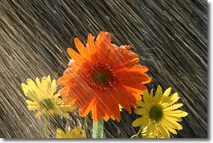
Weather Topic: What is Rain?
Home - Education - Precipitation - Rain
 Next Topic: Shelf Clouds
Precipitation in the form of water droplets is called rain.
Rain generally has a tendency to fall with less intensity over a greater period
of time, and when rainfall is more severe it is usually less sustained.
Rain is the most common form of precipitation and happens with greater frequency
depending on the season and regional influences. Cities have been shown to have
an observable effect on rainfall, due to an effect called the urban heat island.
Compared to upwind, monthly rainfall between twenty and forty miles downwind of
cities is 30% greater.
Next Topic: Shelf Clouds
Current conditions powered by WeatherAPI.com


