Weather Alert in Nebraska
Fire Weather Watch issued March 19 at 2:11PM CDT until March 22 at 4:00AM CDT by NWS North Platte NE
AREAS AFFECTED: Eastern Panhandle/Crescent Lake NWR
DESCRIPTION: ...FIRE WEATHER WATCH IN EFFECT FROM SATURDAY MORNING THROUGH LATE SATURDAY NIGHT FOR RECORD HEAT, LOW HUMIDITY, GUSTY WEST AFTERNOON WINDS, AND A SHARP FRONT WITH STRONG NORTH WINDS LATE FOR ALL OF WESTERN AND NORTH CENTRAL NEBRASKA... * AFFECTED AREA...Fire Weather Zone 204 Eastern Panhandle/Crescent Lake NWR. * TIMING...Red Flag Warning in effect until 7 PM MDT this evening. Fire Weather Watch in effect Saturday morning through late Saturday night. * WINDS...West 10 to 15 mph with gusts up to 25 mph this afternoon. West 10 to 20 mph with gusts up to 30 mph Saturday afternoon, increasing up to 45 mph out of the north late behind a passing front. * RELATIVE HUMIDITY...As low as 9 percent both today and Saturday. * TEMPERATURES...Low to middle 80s Thursday, upper 80s to lower 90s Saturday. * LIGHTNING...None expected either day. * IMPACTS...Any fire starts will have a high potential to spread rapidly and will be difficult to control. * ADDITIONAL DETAILS...A sharp frontal boundary will arrive from the north late in the day Saturday, producing an abrupt wind shift and gusts up to 45 mph during the evening and overnight hours.
INSTRUCTION: A Red Flag Warning means that critical fire weather conditions are either occurring now, or will shortly. A combination of strong winds, low relative humidity, and warm temperatures can contribute to extreme fire behavior. A Fire Weather Watch means that critical fire weather conditions are forecast to occur. Listen for later forecasts and possible Red Flag Warnings.
Want more detail? Get the Complete 7 Day and Night Detailed Forecast!
Current U.S. National Radar--Current
The Current National Weather Radar is shown below with a UTC Time (subtract 5 hours from UTC to get Eastern Time).

National Weather Forecast--Current
The Current National Weather Forecast and National Weather Map are shown below.

National Weather Forecast for Tomorrow
Tomorrow National Weather Forecast and Tomorrow National Weather Map are show below.

North America Water Vapor (Moisture)
This map shows recent moisture content over North America. Bright and colored areas show high moisture (ie, clouds); brown indicates very little moisture present; black indicates no moisture.

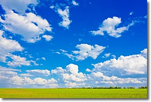
Weather Topic: What are Cumulus Clouds?
Home - Education - Cloud Types - Cumulus Clouds
 Next Topic: Drizzle
Cumulus clouds are fluffy and textured with rounded tops, and
may have flat bottoms. The border of a cumulus cloud
is clearly defined, and can have the appearance of cotton or cauliflower.
Cumulus clouds form at low altitudes (rarely above 2 km) but can grow very tall,
becoming cumulus congestus and possibly the even taller cumulonimbus clouds.
When cumulus clouds become taller, they have a greater chance of producing precipitation.
Next Topic: Drizzle
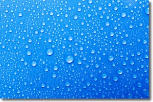
Weather Topic: What is Evaporation?
Home - Education - Precipitation - Evaporation
 Next Topic: Fog
Evaporation is the process which returns water from the earth
back to the atmosphere, and is another crucial process in the water cycle.
Evaporation is the transformation of liquid into gas, and it happens because
molecules are excited by the application of energy and turn into vapor.
In order for water to evaporate it has to be on the surface of a body of water.
Next Topic: Fog
Current conditions powered by WeatherAPI.com


